
Local-Intake Area for Sutherland Dianella Primary School
Many schools have what is termed a 'local-intake area’. This is a boundary set around a school that may have more applications for enrolment than it can accommodate.
If your school has a local-intake area and your usual place of residence is within that area, your children are automatically accepted into that school – this is your guaranteed place. You are encouraged to enrol as soon as you can so the school can plan for your child.
Sutherland Dianella Primary School is a 'local-intake area' school. Click HERE to see an overview of the local-intake area for Sutherland Dianella Primary School. (Click HERE for a more detailed version).
The following defines the local-intake area of this school:
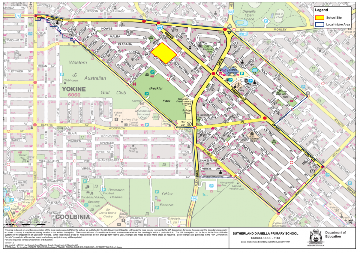
SUTHERLAND DIANELLA PRIMARY SCHOOL (Government Gazette Jan 1997)
The boundary for this school is as follows:
From the intersection of Alexander Drive and Morley Drive, west along Morley Drive to Flinders Street, south along Flinders Street to the westerly extension of Williams Road, east to and south-east along Williams Road and its extension to Cresswell Road, southeast along Cresswell Road to Woodrow Avenue, east along Woodrow Avenue to Alexander Drive, south along Alexander Drive to Wordsworth Avenue, east along Wordsworth Avenue to Homer Street, southeast along Homer Street to Walter Road West, northeast along Walter Road West to Grand Promenade, northwest along Grand Promenade to Surrey Street, northeast along Surrey Street to The Strand, northwest along The Strand to Alexander Drive and north along Alexander Drive to Morley Drive.
The boundary parts of Morley Drive (south side), Flinders Street (east side), Williams Road (both sides), Cresswell Road (both sides), Alexander Drive (east side), Wordsworth Avenue (both sides), Homer Street (both sides), Walter Road West (northwest side), Grand Promenade (southwest side), Surrey Street (northwest side) and The Strand (southwest side) are included within the area for Sutherland Dianella Primary School, while the boundary parts of Woodrow Avenue (both sides) are excluded form the area for Sutherland Dianella Primary School.
Note
The local-intake area maps are based on a written description of the local-intake area (LIA) for the school as published in the WA Government Gazette. Although the map closely represents the LIA description, for some houses near the boundary (especially on street corners), it may be necessary to refer to the written description. The street address of a residence is used to determine whether that dwelling is inside a particular LIA. While local-intake areas for most schools do not change from year to year, changes may be made to local-intake areas as required. Such changes are published in the WA Government Gazette and subsequently the local-intake area map will be updated.
To find another school in your area, please visit the Department of Education website.
Please note: Some schools do not have local-intake areas. In each of these schools, if the number of enrolment applications exceeds the number of places available at a school, priority is given to those children who live closest to the school.
Click HERE for information regarding Pre Primary to Year 6 ENROLMENTS.
Click HERE for information regarding Kindergarten ENROLMENTS.